Lort River Project: Rare Earth Elements
(REE) and Nickel/Copper
Ownership: 100%
Terrain Minerals Limited
Size: 81km2
Location: 650 kilometres southeast Perth (or 50 kilometres northwest of Esperance) within the Albany-Fraser Belt of Western Australia.
Background: The
Lort River Project is located within the Albany-Fraser Belt of Western
Australia. This region is home to two important mining operations: AngloGold
Ashanti’s Tropicana Gold Mine and IGO’s Nova-Bollinger Nickel-Copper Mine.
Strategic
Location: Benefits from
proximity to mining infrastructure and is located in lightly explored
arable farming land.
Rare
Earths Discovery: Confirmed potential for high-demand magnet Rare
Earths Neodymium (Nd) and Praseodymium (Pr), critical for global
industries.
Promising
Geological Findings:
- New
clay target zones identified along the margins of a 5km x 3km circular
mafic intrusive feature.
- January
2025 RC drilling revealed significant results:
- 8m
@ 4,049ppm TREO from 23m (incl. 1m @ 9,840ppm and 1m @ 9,026ppm TREO) (see ASX: 26/03/2025).
- Grades
compare favourably to leading Australian and Brazilian projects.
- Reprocessed VTEM Airborne electromagnetic
survey completed over the Lort River Project successfully mapped the
extent, thickness and depth of the conductive regolith horizons (see ASX: 28/10/2025).
- Scale of interpreted basin exceeds 12
kilometres in length and 5.5 kilometres in width (66 square kilometres).
Accelerated
Exploration Proposed:
- Initial
metallurgical testing underway, with results expected mid-2025.
- Follow-up
air-core drilling program in planning.
Global
Interest: Positioned to attract investment from USA, EU, and Northeast
Asia (Japan and Korea) seeking secure, ex-China supply of critical
minerals.
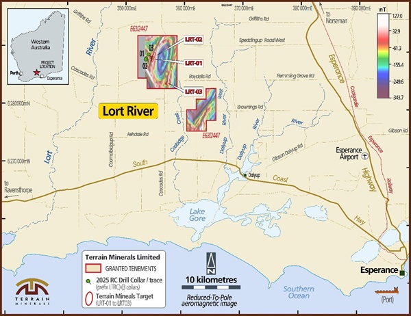
Diagram: Terrain Minerals’
100% owned Lort River Project located in the Albany Fraser belt and is located
50 kilometres northwest of Esperance.
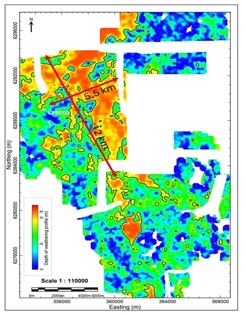
Diagram: Histogram colour
image of the depth to the basement within the Lort River Project based on
inversion modelling of company-acquired airborne electromagnetic
data with 25 metre depth
contours highlighted (white area due to power lines) see ASX:
28/10/2025.
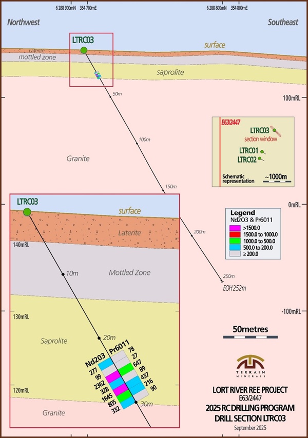
Diagram: Cross section of
drill hole LTRC03 as reported by Terrain Minerals via the ASX Market
Announcements Platform on 26 March 2025.